![](/images/other/stat-length.png)
![Trail Walking La Goulafrière - Circuit de la Grande Vallée - La Goulafrière - Photo](https://media.geolcdn.com/t/1900/400/ext.pjpeg?maxdim=2&url=https%3A%2F%2Fservices.sitytrail.com%2FGeolivesWS%2FDownloadMedia.ashx%3FTrailID%3D110461%26Media%3D5968_1.jpg)
Circuit de la Grande Vallée - La Goulafrière
tracegps
User
![Length](/images/other/stat-length.png)
Length
11.2 km
![Max alt](https://static1.geolcdn.com/siteimages/upload/files/1508320355ic_sort_altitude_max_24dp.png)
Max alt
205 m
![Uphill gradient](https://static1.geolcdn.com/siteimages/upload/files/1508320355ic_sort_den_pos_24dp.png)
Uphill gradient
144 m
![Km-Effort](/images/other/stat-length.png)
Km-Effort
13.1 km
![Min alt](https://static1.geolcdn.com/siteimages/upload/files/1508320355ic_sort_altitude_min_24dp.png)
Min alt
145 m
![Downhill gradient](https://static1.geolcdn.com/siteimages/upload/files/1508320355ic_sort_den_neg_24dp.png)
Downhill gradient
144 m
![Boucle](https://static1.geolcdn.com/siteimages/upload/files/16400158638029165_repeat_loop_refresh_sync_direction_icon.png)
Boucle
Yes
Creation date :
2014-12-10 00:00:00.0
Updated on :
2014-12-10 00:00:00.0
![Walking](https://static1.geolcdn.com/sitytour/trail-icons/101.png)
2h45
Difficulty : Medium
![Scan this QR Code to open this trail in the SityTrail application](https://capi.geolives.com/qq0zvz2zws4bq2lad0pu/sitytour/trails/110461/qr.png?size=200)
FREE GPS app for hiking
About
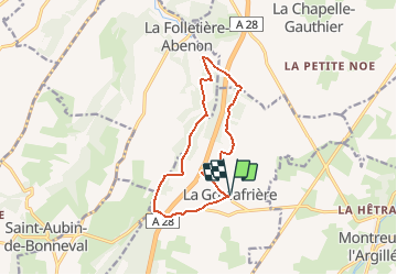
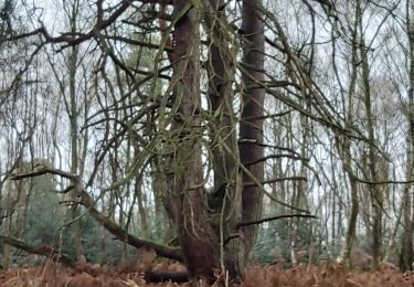
Trail Walking of 11.2 km to be discovered at Normandy, Eure, La Goulafrière. This trail is proposed by tracegps.
Description
Circuit proposé par la Communauté de Communes du canton de Broglie. Départ de la mairie de La Goulafrière. Ce circuit a été numérisé par les randonneurs du CODEPEM. Merci à Jean-Marie.
Positioning
Country:
France
Region :
Normandy
Department/Province :
Eure
Municipality :
La Goulafrière
Location:
Unknown
Start:(Dec)
Start:(UTM)
312310 ; 5425045 (31U) N.
Comments
Trails nearby
![Trail Walking La Chapelle-Gauthier - La Mare Péreuse - La Chapelle-Gauthier - Photo](https://media.geolcdn.com/t/375/260/ext.jpg?maxdim=2&url=https%3A%2F%2Fservices.sitytrail.com%2FGeolivesWS%2FDownloadMedia.ashx%3FTrailID%3D110446%26Media%3D5936_3.jpg)
![Walking Walking](https://static1.geolcdn.com/sitytour/trail-icons/101.png)
La Mare Péreuse - La Chapelle-Gauthier
Walking
Medium
La Chapelle-Gauthier,
Normandy,
Eure,
France
![](/images/other/stat-length.png)
10.3 km | 11.9 km-effort
2h 45min
![](https://static1.geolcdn.com/siteimages/upload/files/16400158638029165_repeat_loop_refresh_sync_direction_icon.png)
Yes
![Trail Walking Montreuil-l'Argillé - autour de Montreuil l argilleé - Photo](https://media.geolcdn.com/t/375/260/38c38167-b310-406a-995f-a8d9a500d0cd.jpg&format=jpg&maxdim=2)
![Walking Walking](https://static1.geolcdn.com/sitytour/trail-icons/101.png)
autour de Montreuil l argilleé
Walking
Very easy
Montreuil-l'Argillé,
Normandy,
Eure,
France
![](/images/other/stat-length.png)
5.3 km | 6.2 km-effort
1h 11min
![](https://static1.geolcdn.com/siteimages/upload/files/16400158638029165_repeat_loop_refresh_sync_direction_icon.png)
Yes
![Trail Cycle Montreuil-l'Argillé - Boucle des mottes féodales - Montreuil-l'Argillé - Photo](https://media.geolcdn.com/t/375/260/ext.jpg?maxdim=2&url=https%3A%2F%2Fservices.sitytrail.com%2FGeolivesWS%2FDownloadMedia.ashx%3FTrailID%3D110415%26Media%3D5889_1.jpg)
![Cycle Cycle](https://static1.geolcdn.com/sitytour/trail-icons/200.png)
Boucle des mottes féodales - Montreuil-l'Argillé
Cycle
Difficult
Montreuil-l'Argillé,
Normandy,
Eure,
France
![](/images/other/stat-length.png)
24 km | 27 km-effort
1h 30min
![](https://static1.geolcdn.com/siteimages/upload/files/16400158638029165_repeat_loop_refresh_sync_direction_icon.png)
Yes
![Trail Walking La Folletière-Abenon - Source de l'Orbiquet avec Cressonnière - Photo](https://media.geolcdn.com/t/375/260/ext.jpg?maxdim=2&url=https%3A%2F%2Fstatic1.geolcdn.com%2Fsiteimages%2Fupload%2Ffiles%2F1553511878bg_sport_marche.png)
![Walking Walking](https://static1.geolcdn.com/sitytour/trail-icons/101.png)
Source de l'Orbiquet avec Cressonnière
Walking
Easy
La Folletière-Abenon,
Normandy,
Calvados,
France
![](/images/other/stat-length.png)
14.1 km | 17.5 km-effort
3h 58min
![](https://static1.geolcdn.com/siteimages/upload/files/16400158638029165_repeat_loop_refresh_sync_direction_icon.png)
Yes
![Trail Walking Montreuil-l'Argillé - Montreuil L'Argillė - Photo](https://media.geolcdn.com/t/375/260/ext.jpg?maxdim=2&url=https%3A%2F%2Fstatic1.geolcdn.com%2Fsiteimages%2Fupload%2Ffiles%2F1553511878bg_sport_marche.png)
![Walking Walking](https://static1.geolcdn.com/sitytour/trail-icons/101.png)
Montreuil L'Argillė
Walking
Medium
Montreuil-l'Argillé,
Normandy,
Eure,
France
![](/images/other/stat-length.png)
9.2 km | 10.8 km-effort
2h 20min
![](https://static1.geolcdn.com/siteimages/upload/files/16400158638029165_repeat_loop_refresh_sync_direction_icon.png)
Yes
![Trail On foot La Folletière-Abenon - Les Sources de l'Orbiquet - Photo](https://media.geolcdn.com/t/375/260/ext.jpg?maxdim=2&url=https%3A%2F%2Fstatic1.geolcdn.com%2Fsiteimages%2Fupload%2Ffiles%2F1545311037marcheuse_200dpi.jpg)
![On foot On foot](https://static1.geolcdn.com/sitytour/trail-icons/100.png)
Les Sources de l'Orbiquet
On foot
Easy
La Folletière-Abenon,
Normandy,
Calvados,
France
![](/images/other/stat-length.png)
3.7 km | 4.4 km-effort
59min
![](https://static1.geolcdn.com/siteimages/upload/files/16400158638029165_repeat_loop_refresh_sync_direction_icon.png)
No
![Trail Walking La Folletière-Abenon - la folletière abenon - Photo](https://media.geolcdn.com/t/375/260/ext.jpg?maxdim=2&url=https%3A%2F%2Fstatic1.geolcdn.com%2Fsiteimages%2Fupload%2Ffiles%2F1553511878bg_sport_marche.png)
![Walking Walking](https://static1.geolcdn.com/sitytour/trail-icons/101.png)
la folletière abenon
Walking
Medium
La Folletière-Abenon,
Normandy,
Calvados,
France
![](/images/other/stat-length.png)
12.1 km | 14.6 km-effort
3h 17min
![](https://static1.geolcdn.com/siteimages/upload/files/16400158638029165_repeat_loop_refresh_sync_direction_icon.png)
Yes
![Trail Walking La Folletière-Abenon - la folletière abenon - Photo](https://media.geolcdn.com/t/375/260/ext.jpg?maxdim=2&url=https%3A%2F%2Fstatic1.geolcdn.com%2Fsiteimages%2Fupload%2Ffiles%2F1553511878bg_sport_marche.png)
![Walking Walking](https://static1.geolcdn.com/sitytour/trail-icons/101.png)
la folletière abenon
Walking
Easy
La Folletière-Abenon,
Normandy,
Calvados,
France
![](/images/other/stat-length.png)
36 km | 42 km-effort
4h 25min
![](https://static1.geolcdn.com/siteimages/upload/files/16400158638029165_repeat_loop_refresh_sync_direction_icon.png)
No
![Trail Walking La Goulafrière - La Goulafriere 27 - Photo](https://media.geolcdn.com/t/375/260/57bcf86c-5668-45d7-9473-13e9f837b6a9.jpg&format=jpg&maxdim=2)
![Walking Walking](https://static1.geolcdn.com/sitytour/trail-icons/101.png)
La Goulafriere 27
Walking
Easy
La Goulafrière,
Normandy,
Eure,
France
![](/images/other/stat-length.png)
11.9 km | 13.9 km-effort
3h 8min
![](https://static1.geolcdn.com/siteimages/upload/files/16400158638029165_repeat_loop_refresh_sync_direction_icon.png)
Yes